Boundaries
At the core of wombat is the "boundary" which selects the regions (or polygons) on which everything is based. It is set at the outset and then all data in question relates to the objects in those areas. Rather than making wombat specific to just the capital cities or the top N populated cities, we enable any scale analyses.
Statistical Areas In Wombat
Let's first review the Australian Statistical Area Standard in the following diagram and how these are coded in Wombat.
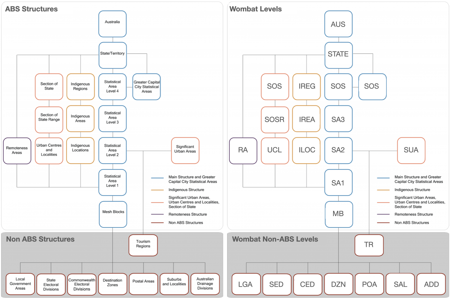
On the left we have the Statistical Areas from the Australian Statistical Geography Standard (ASGS). On the right, we have the code adopted in wombat to refer to those levels. Given the natural hierarchical structure of these nested statistical areas, it lends itself well to a directed network.
The most widely used library for handling these kinds of structures is networkx. This is what is used in wombat to manage connections between statistical areas at different spatial scales.
Exploring The Graph Of Statistical Areas
Let's now first explore the scales of these regions in Australia. Please first see our primer on the core Statistical Area concepts first if you are unfamiliar with how this is managed by the government in Australia.
First all the statistical area from the ASGS website (download here) was downloaded and processed as a hierarchical tree. The GeoHierarchy (link) was developed to process these GPKG files and create the networkx graph connecting all of the regions in Australia. Once fully constructed, the total number of nodes is 464305 (areas) with 464802 edges (connections) and is ~1.65GB (gpickle format). This graph is accessibly via wombat.Boundary.graph.G but more convenient abstractions have been developed to perform specific geospatial manipulations.
Let's explore some of these below:
import wombat,os
w = wombat.Wombat(os.environ['WOMBAT_DATA_PATH'])
w.Boundary.graph # GeoHierarchy handler for Australian statistical areas
w.Boundary.graph.G # networkx graph object
<networkx.classes.digraph.DiGraph at 0x2af996d00>
The two core attributes of each node or statistical area is the level and the label.
- The
levelrefers to the above categories, e.g.SA4orGCCSA. - The
labelrefers to the name of the statistical are, e.g.Greater Brisbane, orQueensland.
We can get a summary of the codes from above to remind us as follows
w.Boundary.info
ADD Australian Drainage Divisions are an ABS Mesh ... ALL None AUS Australia (AUS) is the largest region in the A... CED Commonwealth Electoral Divisions are an ABS Me... DZN Destination Zones are co-designed with state a... GCCSA Greater Capital City Statistical Areas (GCCSAs... IARE Indigenous Areas (IAREs) are medium sized geog... ILOC Indigenous Locations (ILOCs) represent small A... IREG Indigenous Regions (IREGs) are large geographi... LGA Local Government Areas are an ABS Mesh Block r... MB Mesh Blocks (MBs) are the smallest geographic ... POA Postal Areas are an ABS Mesh Block approximati... SA1 Statistical Areas Level 1 (SA1s) are designed ... SA2 Statistical Areas Level 2 (SA2s) are medium-si... SA3 Statistical Areas Level 3 (SA3s) are designed ... SA4 Statistical Areas Level 4 (SA4s) are designed ... SAL Suburbs and Localities (formerly State Suburbs... SED State Electoral Divisions are an ABS Mesh Bloc... SOS Section of State (SOS) groups the UCLs into cl... SOSR Section of State Range (SOSR) provides a more ... STATE States and Territories (S/T) are a cartographi... SUA Significant Urban Areas (SUAs) represent indiv... TR Tourism Regions are an ABS SA2 approximation o... UCL Urban Centres and Localities (UCLs) are aggreg... dtype: object
w.Boundary.info['TR']
'Tourism Regions are an ABS SA2 approximation of tourism regions as provided by Tourism Research Australia.'
Let's make a quick function to check how many we have at each level.
#Or just accessible via
w.Boundary.graph.level_counts
{'AUS': 1,
'STATE': 9,
'GCCSA': 34,
'SA4': 107,
'SA3': 358,
'SA2': 2475,
'SA1': 61844,
'MB': 368285,
'SAL': 15007,
'ADD': 16,
'TR': 76,
'CED': 72,
'SED': 103,
'DZN': 9328,
'POA': 2643,
'LGA': 385,
'SOS': 52,
'SOSR': 41,
'UCL': 1836,
'SUA': 70,
'IREG': 8,
'IARE': 416,
'ILOC': 1138}
e.g. The root node AUS (Australia) has one node and the STATE code has 9 states & territories, 368k mesh blocks, 8 Indigenous Regions etc. Let's now take a look at a sub-graph of say a Greater Capital City Area and it's "child areas" or nodes.
brisbane_node = w.Boundary.get_boundary(label="Greater Brisbane",level=None)
brisbane_node
| label | uri | geometry | area_sqkm | level | |
|---|---|---|---|---|---|
| 3GBRI | Greater Brisbane | http://linked.data.gov.au/dataset/asgsed3/GCCS... | MULTIPOLYGON (((153.23213 -27.42089, 153.23179... | 15842.0073 | GCCSA |
# note network operations are applied on the graph, not at
subG = w.Boundary.graph.get_subnetwork(brisbane_node, depth=1,remove_geometry=True)
brisbane_node
| label | uri | geometry | area_sqkm | level | |
|---|---|---|---|---|---|
| 3GBRI | Greater Brisbane | http://linked.data.gov.au/dataset/asgsed3/GCCS... | MULTIPOLYGON (((153.23213 -27.42089, 153.23179... | 15842.0073 | GCCSA |
Common Queries
We may want to access all the regions of a particular level. wombat has a number of helpder functions, for example.
# get country boundary
gdf = w.Boundary.get_country()
gdf
| label | uri | geometry | area_sqkm | level | |
|---|---|---|---|---|---|
| AUS | Australia | http://linked.data.gov.au/dataset/asgsed3/AUS/AUS | MULTIPOLYGON (((96.91524 -12.15313, 96.91528 -... | 7.688095e+06 | AUS |
# get state boundary
gdf = w.Boundary.get_states()
gdf
| label | uri | geometry | area_sqkm | level | |
|---|---|---|---|---|---|
| 8 | Australian Capital Territory | http://linked.data.gov.au/dataset/asgsed3/STE/8 | MULTIPOLYGON (((149.06239 -35.15910, 149.06152... | 2.358133e+03 | STATE |
| 1 | New South Wales | http://linked.data.gov.au/dataset/asgsed3/STE/1 | MULTIPOLYGON (((159.06230 -31.50886, 159.06244... | 8.007977e+05 | STATE |
| 7 | Northern Territory | http://linked.data.gov.au/dataset/asgsed3/STE/7 | MULTIPOLYGON (((133.02818 -10.90839, 133.02631... | 1.348134e+06 | STATE |
| 9 | Other Territories | http://linked.data.gov.au/dataset/asgsed3/STE/9 | MULTIPOLYGON (((167.94747 -29.12757, 167.94739... | 2.557420e+02 | STATE |
| 3 | Queensland | http://linked.data.gov.au/dataset/asgsed3/STE/3 | MULTIPOLYGON (((142.53140 -10.68301, 142.53232... | 1.730171e+06 | STATE |
| 4 | South Australia | http://linked.data.gov.au/dataset/asgsed3/STE/4 | MULTIPOLYGON (((140.66025 -38.06256, 140.66046... | 9.842314e+05 | STATE |
| 6 | Tasmania | http://linked.data.gov.au/dataset/asgsed3/STE/6 | MULTIPOLYGON (((144.60439 -41.01001, 144.60437... | 6.801754e+04 | STATE |
| 2 | Victoria | http://linked.data.gov.au/dataset/asgsed3/STE/2 | MULTIPOLYGON (((146.29286 -39.15778, 146.29275... | 2.274962e+05 | STATE |
| 5 | Western Australia | http://linked.data.gov.au/dataset/asgsed3/STE/5 | MULTIPOLYGON (((117.86953 -35.19108, 117.86945... | 2.526632e+06 | STATE |
# get a specific state
gdf = w.Boundary.get_state("Queensland")
gdf
| label | uri | geometry | area_sqkm | level | |
|---|---|---|---|---|---|
| 3 | Queensland | http://linked.data.gov.au/dataset/asgsed3/STE/3 | MULTIPOLYGON (((142.53140 -10.68301, 142.53232... | 1.730171e+06 | STATE |
# get indigenous regions
gdf = w.Boundary.get_indigenous_regions()
gdf
| label | uri | geometry | area_sqkm | level | |
|---|---|---|---|---|---|
| 708 | Alice Springs | http://linked.data.gov.au/dataset/asgsed3/IREG... | MULTIPOLYGON (((133.91952 -23.66479, 133.91951... | 327.7132 | IREG |
| 709 | Apatula | http://linked.data.gov.au/dataset/asgsed3/IREG... | MULTIPOLYGON (((137.99876 -23.87195, 137.99865... | 569272.6927 | IREG |
| 704 | Jabiru - Tiwi | http://linked.data.gov.au/dataset/asgsed3/IREG... | MULTIPOLYGON (((129.69308 -14.80637, 129.69361... | 104472.1761 | IREG |
| 902 | Jervis Bay | http://linked.data.gov.au/dataset/asgsed3/IREG... | MULTIPOLYGON (((150.71526 -35.13088, 150.71512... | 67.2296 | IREG |
| 705 | Katherine | http://linked.data.gov.au/dataset/asgsed3/IREG... | MULTIPOLYGON (((137.41178 -16.14504, 137.40920... | 321835.2135 | IREG |
| 706 | Nhulunbuy | http://linked.data.gov.au/dataset/asgsed3/IREG... | MULTIPOLYGON (((135.61089 -14.53645, 135.61170... | 38025.1366 | IREG |
| 903 | Norfolk Island | http://linked.data.gov.au/dataset/asgsed3/IREG... | MULTIPOLYGON (((167.94646 -29.13597, 167.94667... | 38.6510 | IREG |
| 707 | Tennant Creek | http://linked.data.gov.au/dataset/asgsed3/IREG... | MULTIPOLYGON (((135.75459 -16.95373, 135.70637... | 303211.1804 | IREG |
#get greater capital city areas
gdf = w.Boundary.get_gccs()
gdf
| label | uri | geometry | area_sqkm | level | |
|---|---|---|---|---|---|
| 8ACTE | Australian Capital Territory | http://linked.data.gov.au/dataset/asgsed3/GCCS... | MULTIPOLYGON (((149.06239 -35.15910, 149.06152... | 2358.1330 | GCCSA |
| 4GADE | Greater Adelaide | http://linked.data.gov.au/dataset/asgsed3/GCCS... | MULTIPOLYGON (((138.65522 -34.55213, 138.65502... | 3259.8859 | GCCSA |
| 3GBRI | Greater Brisbane | http://linked.data.gov.au/dataset/asgsed3/GCCS... | MULTIPOLYGON (((153.23213 -27.42089, 153.23179... | 15842.0073 | GCCSA |
| 7GDAR | Greater Darwin | http://linked.data.gov.au/dataset/asgsed3/GCCS... | MULTIPOLYGON (((131.03248 -12.05831, 131.03443... | 3167.7034 | GCCSA |
| 6GHOB | Greater Hobart | http://linked.data.gov.au/dataset/asgsed3/GCCS... | MULTIPOLYGON (((147.60058 -42.86784, 147.60065... | 1695.3611 | GCCSA |
| 2GMEL | Greater Melbourne | http://linked.data.gov.au/dataset/asgsed3/GCCS... | MULTIPOLYGON (((144.88829 -38.50260, 144.88826... | 9992.6081 | GCCSA |
| 5GPER | Greater Perth | http://linked.data.gov.au/dataset/asgsed3/GCCS... | MULTIPOLYGON (((115.66990 -32.19610, 115.67003... | 6416.5721 | GCCSA |
| 1GSYD | Greater Sydney | http://linked.data.gov.au/dataset/asgsed3/GCCS... | MULTIPOLYGON (((151.28159 -33.83318, 151.28167... | 12368.6858 | GCCSA |
Advanced Queries
Coming soon...
Visualising Statistical Areas
We can then simply add these GeoPandas dataframes to our wombat leaflet map as easily as follows:
w.add_nodes_to_map(brisbane_node)
w
We can access functions of the graph as normal, eg. because it is a DiGraph, we can add the next level down to the map as well (in this case, SA4).
Or on a more practical level (geopandas)
brisbane_node_children = w.Boundary.get_boundaries_down(brisbane_node)
brisbane_node_children
| label | uri | geometry | area_sqkm | level | |
|---|---|---|---|---|---|
| 0 | Brisbane - East | http://linked.data.gov.au/dataset/asgsed3/SA4/301 | MULTIPOLYGON (((153.22243 -27.39012, 153.22243... | 653.1329 | SA4 |
| 1 | Brisbane - North | http://linked.data.gov.au/dataset/asgsed3/SA4/302 | MULTIPOLYGON (((153.05930 -27.41036, 153.05965... | 186.9483 | SA4 |
| 2 | Brisbane - South | http://linked.data.gov.au/dataset/asgsed3/SA4/303 | MULTIPOLYGON (((153.11638 -27.48653, 153.11606... | 265.3445 | SA4 |
| 3 | Brisbane - West | http://linked.data.gov.au/dataset/asgsed3/SA4/304 | MULTIPOLYGON (((152.94973 -27.52916, 152.94954... | 269.6508 | SA4 |
| 4 | Brisbane Inner City | http://linked.data.gov.au/dataset/asgsed3/SA4/305 | MULTIPOLYGON (((153.03520 -27.41424, 153.03491... | 81.7393 | SA4 |
| 5 | Ipswich | http://linked.data.gov.au/dataset/asgsed3/SA4/310 | MULTIPOLYGON (((152.97064 -27.54878, 152.97056... | 6681.1781 | SA4 |
| 6 | Logan - Beaudesert | http://linked.data.gov.au/dataset/asgsed3/SA4/311 | MULTIPOLYGON (((153.20809 -27.64496, 153.20751... | 2586.1630 | SA4 |
| 7 | Moreton Bay - North | http://linked.data.gov.au/dataset/asgsed3/SA4/313 | MULTIPOLYGON (((153.12103 -26.84384, 153.12112... | 4344.4557 | SA4 |
| 8 | Moreton Bay - South | http://linked.data.gov.au/dataset/asgsed3/SA4/314 | MULTIPOLYGON (((153.01593 -27.20804, 153.01619... | 773.3947 | SA4 |
| 9 | Capalaba | http://linked.data.gov.au/dataset/asgsed3/SA3/... | MULTIPOLYGON (((153.12472 -27.50282, 153.12466... | 89.2962 | SA3 |
Which can then just be added to the leaflet map as normal
w.add_gdf(brisbane_node_children)
w
There are other inspection like functions to assist in inspecting the graph as well.
w.Boundary.graph.print_tree(node,depth=1,children=True,parents=True,cousins=False)
Parents of Greater Brisbane: > Queensland (1730171km2) > Australia (7688094km2) Children of Greater Brisbane: > Brisbane - East (653km2) > Brisbane - North (186km2) > Brisbane - South (265km2) > Brisbane - West (269km2) > Brisbane Inner City (81km2) > Ipswich (6681km2) > Logan - Beaudesert (2586km2) > Moreton Bay - North (4344km2) > Moreton Bay - South (773km2) > Capalaba (89km2)
w.set_area("AUS")
Filtering particular levels based on a parent label (e.g. LGA level is higher up the tree so the label "Queensland" appears and thus the child node is included). Let's see this in practice.
lgas = w.Boundary.get_lgas("Queensland")
lgas
| label | uri | geometry | area_sqkm | level | |
|---|---|---|---|---|---|
| 0 | Gladstone | https://linked.data.gov.au/dataset/asgsed3/LGA... | MULTIPOLYGON (((151.04991 -23.43144, 151.05065... | 10484.2861 | LGA |
| 1 | Gold Coast | https://linked.data.gov.au/dataset/asgsed3/LGA... | MULTIPOLYGON (((153.44036 -27.74045, 153.44042... | 1333.3860 | LGA |
| 2 | Goondiwindi | https://linked.data.gov.au/dataset/asgsed3/LGA... | MULTIPOLYGON (((149.58824 -28.57381, 149.58848... | 19265.7098 | LGA |
| 3 | Gympie | https://linked.data.gov.au/dataset/asgsed3/LGA... | MULTIPOLYGON (((153.04862 -25.83535, 153.04885... | 6883.9781 | LGA |
| 4 | Hinchinbrook | https://linked.data.gov.au/dataset/asgsed3/LGA... | MULTIPOLYGON (((146.48544 -18.61668, 146.48604... | 2807.1889 | LGA |
| 5 | Hope Vale | https://linked.data.gov.au/dataset/asgsed3/LGA... | MULTIPOLYGON (((145.23873 -15.44338, 145.23909... | 1111.7099 | LGA |
| 6 | Ipswich | https://linked.data.gov.au/dataset/asgsed3/LGA... | MULTIPOLYGON (((152.87878 -27.58175, 152.87738... | 1093.8562 | LGA |
| 7 | Isaac | https://linked.data.gov.au/dataset/asgsed3/LGA... | MULTIPOLYGON (((150.43471 -21.77199, 150.43500... | 58707.9192 | LGA |
| 8 | Kowanyama | https://linked.data.gov.au/dataset/asgsed3/LGA... | MULTIPOLYGON (((141.59100 -15.19652, 141.58609... | 2555.3325 | LGA |
| 9 | Livingstone | https://linked.data.gov.au/dataset/asgsed3/LGA... | MULTIPOLYGON (((150.81649 -23.51945, 150.81695... | 11757.8686 | LGA |
| 10 | Lockhart River | https://linked.data.gov.au/dataset/asgsed3/LGA... | MULTIPOLYGON (((143.61690 -12.98513, 143.61691... | 3576.6839 | LGA |
| 11 | Lockyer Valley | https://linked.data.gov.au/dataset/asgsed3/LGA... | MULTIPOLYGON (((152.49266 -27.55156, 152.49243... | 2269.0054 | LGA |
| 12 | Logan | https://linked.data.gov.au/dataset/asgsed3/LGA... | MULTIPOLYGON (((153.11897 -27.59503, 153.11563... | 958.1333 | LGA |
| 13 | Longreach | https://linked.data.gov.au/dataset/asgsed3/LGA... | MULTIPOLYGON (((143.24891 -22.84028, 143.24350... | 40572.2442 | LGA |
| 14 | Mackay | https://linked.data.gov.au/dataset/asgsed3/LGA... | MULTIPOLYGON (((149.00466 -20.42480, 149.00656... | 7613.2963 | LGA |
| 16 | Mapoon | https://linked.data.gov.au/dataset/asgsed3/LGA... | MULTIPOLYGON (((142.12878 -12.39173, 142.20453... | 537.2366 | LGA |
| 17 | Maranoa | https://linked.data.gov.au/dataset/asgsed3/LGA... | MULTIPOLYGON (((147.32563 -26.40104, 147.32166... | 58719.3449 | LGA |
| 18 | Mareeba | https://linked.data.gov.au/dataset/asgsed3/LGA... | MULTIPOLYGON (((142.52305 -16.81143, 142.52305... | 53491.0502 | LGA |
| 15 | McKinlay | https://linked.data.gov.au/dataset/asgsed3/LGA... | MULTIPOLYGON (((141.02420 -20.48384, 141.03640... | 40736.7989 | LGA |
| 19 | Moreton Bay | https://linked.data.gov.au/dataset/asgsed3/LGA... | MULTIPOLYGON (((153.07432 -27.00084, 153.07456... | 2041.4737 | LGA |
| 20 | Mornington | https://linked.data.gov.au/dataset/asgsed3/LGA... | MULTIPOLYGON (((139.06136 -16.88929, 139.06019... | 1247.6932 | LGA |
| 21 | Mount Isa | https://linked.data.gov.au/dataset/asgsed3/LGA... | MULTIPOLYGON (((137.99653 -20.22441, 137.99659... | 43715.1975 | LGA |
| 22 | Murweh | https://linked.data.gov.au/dataset/asgsed3/LGA... | MULTIPOLYGON (((145.29360 -26.20847, 145.28284... | 40699.7586 | LGA |
| 23 | Napranum | https://linked.data.gov.au/dataset/asgsed3/LGA... | MULTIPOLYGON (((141.84689 -12.94277, 141.87012... | 2004.3468 | LGA |
| 24 | Noosa | https://linked.data.gov.au/dataset/asgsed3/LGA... | MULTIPOLYGON (((153.09826 -26.38141, 153.09813... | 869.8657 | LGA |
| 25 | North Burnett | https://linked.data.gov.au/dataset/asgsed3/LGA... | MULTIPOLYGON (((150.55759 -25.15600, 150.55748... | 19669.8489 | LGA |
| 26 | Northern Peninsula Area | https://linked.data.gov.au/dataset/asgsed3/LGA... | MULTIPOLYGON (((142.53270 -10.84306, 142.53274... | 1052.0676 | LGA |
| 27 | Palm Island | https://linked.data.gov.au/dataset/asgsed3/LGA... | MULTIPOLYGON (((146.54305 -18.83706, 146.54266... | 71.9928 | LGA |
| 28 | Paroo | https://linked.data.gov.au/dataset/asgsed3/LGA... | MULTIPOLYGON (((144.77983 -28.17364, 144.77504... | 47614.9225 | LGA |
| 29 | Pormpuraaw | https://linked.data.gov.au/dataset/asgsed3/LGA... | MULTIPOLYGON (((141.62055 -14.91857, 141.62067... | 4395.3654 | LGA |
| 30 | Quilpie | https://linked.data.gov.au/dataset/asgsed3/LGA... | MULTIPOLYGON (((142.84406 -27.10525, 142.84579... | 67414.6563 | LGA |
| 31 | Redland | https://linked.data.gov.au/dataset/asgsed3/LGA... | MULTIPOLYGON (((153.29057 -27.53016, 153.29059... | 537.1672 | LGA |
| 32 | Richmond | https://linked.data.gov.au/dataset/asgsed3/LGA... | MULTIPOLYGON (((142.36178 -20.56891, 142.35727... | 26580.7480 | LGA |
| 33 | Rockhampton | https://linked.data.gov.au/dataset/asgsed3/LGA... | MULTIPOLYGON (((150.53135 -23.28778, 150.52987... | 6570.2667 | LGA |
| 34 | Scenic Rim | https://linked.data.gov.au/dataset/asgsed3/LGA... | MULTIPOLYGON (((152.98258 -27.92411, 152.97842... | 4243.0014 | LGA |
| 35 | Somerset | https://linked.data.gov.au/dataset/asgsed3/LGA... | MULTIPOLYGON (((152.23432 -27.21502, 152.23312... | 5373.4335 | LGA |
| 36 | South Burnett | https://linked.data.gov.au/dataset/asgsed3/LGA... | MULTIPOLYGON (((151.12522 -26.31931, 151.12519... | 8381.5580 | LGA |
| 37 | Southern Downs | https://linked.data.gov.au/dataset/asgsed3/LGA... | MULTIPOLYGON (((151.52366 -28.26998, 151.52420... | 7106.4360 | LGA |
| 38 | Sunshine Coast | https://linked.data.gov.au/dataset/asgsed3/LGA... | MULTIPOLYGON (((153.06791 -26.97281, 153.06800... | 2253.8522 | LGA |
| 39 | Tablelands | https://linked.data.gov.au/dataset/asgsed3/LGA... | MULTIPOLYGON (((145.43710 -17.30331, 145.43673... | 11292.8695 | LGA |
| 40 | Toowoomba | https://linked.data.gov.au/dataset/asgsed3/LGA... | MULTIPOLYGON (((151.96203 -26.80464, 151.96176... | 12957.2103 | LGA |
| 41 | Torres | https://linked.data.gov.au/dataset/asgsed3/LGA... | MULTIPOLYGON (((142.35260 -10.54642, 142.35328... | 883.7402 | LGA |
| 42 | Torres Strait Island | https://linked.data.gov.au/dataset/asgsed3/LGA... | MULTIPOLYGON (((142.78198 -9.90153, 142.78196 ... | 490.0453 | LGA |
| 43 | Townsville | https://linked.data.gov.au/dataset/asgsed3/LGA... | MULTIPOLYGON (((146.63250 -19.02410, 146.63248... | 3730.8199 | LGA |
| 44 | Weipa | https://linked.data.gov.au/dataset/asgsed3/LGA... | MULTIPOLYGON (((141.92580 -12.68735, 141.92888... | 10.4643 | LGA |
| 45 | Western Downs | https://linked.data.gov.au/dataset/asgsed3/LGA... | MULTIPOLYGON (((149.68422 -26.77370, 149.66452... | 37922.5007 | LGA |
| 46 | Whitsunday | https://linked.data.gov.au/dataset/asgsed3/LGA... | MULTIPOLYGON (((148.87321 -20.61689, 148.87325... | 23818.9729 | LGA |
| 47 | Winton | https://linked.data.gov.au/dataset/asgsed3/LGA... | MULTIPOLYGON (((141.93928 -21.80666, 141.74048... | 53813.4826 | LGA |
| 48 | Woorabinda | https://linked.data.gov.au/dataset/asgsed3/LGA... | MULTIPOLYGON (((149.40277 -24.62241, 149.40778... | 390.5578 | LGA |
| 49 | Wujal Wujal | https://linked.data.gov.au/dataset/asgsed3/LGA... | MULTIPOLYGON (((145.31582 -15.94589, 145.31226... | 11.8420 | LGA |
| 50 | Yarrabah | https://linked.data.gov.au/dataset/asgsed3/LGA... | MULTIPOLYGON (((145.90107 -16.99399, 145.90150... | 158.8381 | LGA |
w.add_gdf(lgas)
w
sa4s = w.Boundary.get_sa4("Victoria")
sa4s
| label | uri | geometry | area_sqkm | level | |
|---|---|---|---|---|---|
| 0 | Ballarat | http://linked.data.gov.au/dataset/asgsed3/SA4/201 | MULTIPOLYGON (((143.89970 -37.00054, 143.89770... | 10287.4757 | SA4 |
| 1 | Bendigo | http://linked.data.gov.au/dataset/asgsed3/SA4/202 | MULTIPOLYGON (((144.29217 -37.16356, 144.32485... | 11841.9058 | SA4 |
| 2 | Geelong | http://linked.data.gov.au/dataset/asgsed3/SA4/203 | MULTIPOLYGON (((144.68579 -38.24574, 144.68628... | 4428.6990 | SA4 |
| 3 | Hume | http://linked.data.gov.au/dataset/asgsed3/SA4/204 | MULTIPOLYGON (((146.50214 -35.98317, 146.50286... | 34006.4765 | SA4 |
| 4 | Latrobe - Gippsland | http://linked.data.gov.au/dataset/asgsed3/SA4/205 | MULTIPOLYGON (((145.10992 -38.51956, 145.11017... | 41553.1093 | SA4 |
| 5 | Melbourne - Inner | http://linked.data.gov.au/dataset/asgsed3/SA4/206 | MULTIPOLYGON (((145.02062 -37.75442, 145.01886... | 142.4579 | SA4 |
| 6 | Melbourne - Inner East | http://linked.data.gov.au/dataset/asgsed3/SA4/207 | MULTIPOLYGON (((145.16229 -37.73770, 145.16226... | 146.7436 | SA4 |
| 7 | Melbourne - Inner South | http://linked.data.gov.au/dataset/asgsed3/SA4/208 | MULTIPOLYGON (((145.07352 -37.99858, 145.07368... | 161.4964 | SA4 |
| 8 | Melbourne - North East | http://linked.data.gov.au/dataset/asgsed3/SA4/209 | MULTIPOLYGON (((145.05522 -37.28651, 145.05492... | 1851.2647 | SA4 |
| 9 | Melbourne - North West | http://linked.data.gov.au/dataset/asgsed3/SA4/210 | MULTIPOLYGON (((144.95001 -37.51126, 144.94994... | 1619.6884 | SA4 |
| 10 | Melbourne - Outer East | http://linked.data.gov.au/dataset/asgsed3/SA4/211 | MULTIPOLYGON (((145.30018 -37.96573, 145.30105... | 1878.5577 | SA4 |
| 11 | Melbourne - South East | http://linked.data.gov.au/dataset/asgsed3/SA4/212 | MULTIPOLYGON (((145.37259 -38.22249, 145.37940... | 1922.2794 | SA4 |
| 12 | Melbourne - West | http://linked.data.gov.au/dataset/asgsed3/SA4/213 | MULTIPOLYGON (((144.86078 -37.77611, 144.86066... | 1416.3538 | SA4 |
| 13 | Mornington Peninsula | http://linked.data.gov.au/dataset/asgsed3/SA4/214 | MULTIPOLYGON (((144.88829 -38.50260, 144.88826... | 853.7662 | SA4 |
| 14 | North West | http://linked.data.gov.au/dataset/asgsed3/SA4/215 | MULTIPOLYGON (((142.76759 -34.57821, 142.76743... | 78072.9843 | SA4 |
| 15 | Shepparton | http://linked.data.gov.au/dataset/asgsed3/SA4/216 | MULTIPOLYGON (((146.01156 -36.00572, 146.01106... | 10933.8661 | SA4 |
| 16 | Warrnambool and South West | http://linked.data.gov.au/dataset/asgsed3/SA4/217 | MULTIPOLYGON (((142.00870 -38.41715, 142.00871... | 26379.1231 | SA4 |
w.add_gdf(sa4s)
w
One particular study you might want to do would be just the Greater Capital City Statistical Areas
gccs = w.Boundary.get_gccs()
gccs
| label | uri | geometry | area_sqkm | level | |
|---|---|---|---|---|---|
| 28 | Australian Capital Territory | http://linked.data.gov.au/dataset/asgsed3/GCCS... | MULTIPOLYGON (((149.06239 -35.15910, 149.06152... | 2358.1330 | GCCSA |
| 12 | Greater Adelaide | http://linked.data.gov.au/dataset/asgsed3/GCCS... | MULTIPOLYGON (((138.65522 -34.55213, 138.65502... | 3259.8859 | GCCSA |
| 8 | Greater Brisbane | http://linked.data.gov.au/dataset/asgsed3/GCCS... | MULTIPOLYGON (((153.23213 -27.42089, 153.23179... | 15842.0073 | GCCSA |
| 24 | Greater Darwin | http://linked.data.gov.au/dataset/asgsed3/GCCS... | MULTIPOLYGON (((131.03248 -12.05831, 131.03443... | 3167.7034 | GCCSA |
| 20 | Greater Hobart | http://linked.data.gov.au/dataset/asgsed3/GCCS... | MULTIPOLYGON (((147.60058 -42.86784, 147.60065... | 1695.3611 | GCCSA |
| 4 | Greater Melbourne | http://linked.data.gov.au/dataset/asgsed3/GCCS... | MULTIPOLYGON (((144.88829 -38.50260, 144.88826... | 9992.6081 | GCCSA |
| 16 | Greater Perth | http://linked.data.gov.au/dataset/asgsed3/GCCS... | MULTIPOLYGON (((115.66990 -32.19610, 115.67003... | 6416.5721 | GCCSA |
| 0 | Greater Sydney | http://linked.data.gov.au/dataset/asgsed3/GCCS... | MULTIPOLYGON (((151.28159 -33.83318, 151.28167... | 12368.6858 | GCCSA |
| 31 | Other Territories | http://linked.data.gov.au/dataset/asgsed3/GCCS... | MULTIPOLYGON (((167.94747 -29.12757, 167.94739... | 255.7420 | GCCSA |
w.add_gdf(gccs)
w